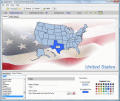
iMapBuilder is an easy-to-use, powerful, WYSIWYG Flash map building tool for non-technical users. It is an all-in-one software that creates professional Flash maps quickly and easily without any programming skills or additional software.
Stitch maps together to build one overall map. Join and calibrate your Google Earth images to one shared map. The program StitchMaps simply joins these maps. The result is a map that is suitable for programs using raster scan.
By placing a sitemap-formatted file on your Web server, you help Google's spiders find which pages on your siteand which have recently changed, and to crawl your site accordingly.
FlashMapOne provides a most effective interactive map solutions for your project. Use FlashMapOne, you can create animated, interactive and data-driven Flash Maps for your dynamic web applications.
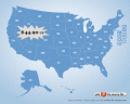
Flash maps suitable for Real-Estate, Dealer Maps, Branch Offices Locators.
Set states clickable with hyperlinks (URL).
Define colour for each state.
Full FLA source file, SWF available.
All adjustment are produced in source FLA.
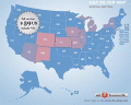
Flash maps suitable for Real-Estate, Dealer Maps, Branch Offices Locators.
Set states clickable with hyperlinks (URL).
Define colour for each area (state).
FULL .FLA source file, SWF available.
All adjustment are produced in source FLA.
Anychart Flash Maps Flexible XML-Driven solution: US, World, US Counties. You can add background and captions, XML data file and a set of customizable options make AnyChart Maps a universal solution for web developers.